Manotick
South

Fast Facts
- Population: 9,040 (City of Ottawa Neighbourhood Study)
- Size: 58.15 km² (Computed from the City of Ottawa Neighbourhood Study boundary polygon)
- Distance from Parliament Hill: About 24.0 km south (straight-line distance)
Overview
Manotick is a historic village on the Rideau River in Ottawa's rural south end, built around Watson's Mill, a fully operational 1860s water-powered flour mill founded by Moss Kent Dickinson and Joseph Currier. Dickinson named the village "Manotick," from the Algonquin-Anishinabe word meaning "island," and registered his plan for the village in 1862; the mill and Dickinson House remain Ottawa's only working industrial heritage museum.
Boundaries
The Ottawa Neighbourhood Study boundary covers Manotick village and a substantial surrounding rural area along the Rideau River, extending south toward Kars and west toward Greely.
Map
History
Moss Kent Dickinson and Joseph Currier leased the water rights to a control dam on the Rideau River in 1858, intending to build a milling complex and a new community. Watson's Mill, built in 1860, became the centrepiece of a complex that at its height included a sawmill, flour mill, carding mill, and bung plug and spile mill.
Dickinson named the new village "Manotick," an Algonquin-Anishinabe word meaning "island," and registered his plan for the Village of Manotick with the County of Carleton in 1862. Dickinson, nicknamed the "King of the Rideau" for his steamboat business along the canal, served as mayor of Ottawa from 1864 to 1866.
Dickinson House, built in 1867, originally served as the mills' office, a general store, and the village post office before becoming the Dickinson family home in 1870. Dickinson Square, the site today, is Ottawa's only industrial heritage site and one of the few operating industrial grist mills left in North America.
Manotick grew steadily through the 20th century as a rural village along the Rideau River and became part of the City of Ottawa with the 2001 amalgamation, retaining its historic village character around Watson's Mill.
Claim to Fame
Manotick's defining feature is Watson's Mill, a fully operational 1860s water-powered flour mill and Ottawa's only working industrial heritage museum, one of very few operating industrial grist mills remaining in North America.
Surrounding Neighbourhoods
Barrhaven lies north across the Rideau River, Greely lies east, and Kars and rural North Grenville lie south along the river.
Architecture
Manotick's village core retains 19th-century mill-town buildings around Watson's Mill and Dickinson Square, while the surrounding rural area mixes long-established acreage properties with newer executive-home development along the river.
Grocery Stores
- McDonough's Your Independent Grocer — Grocery store
Independent Grocer supermarket at 1160 Beaverwood Road.
Visit website
Pedestrian and Cycling
Manotick's village core around Watson's Mill and Dickinson Square is walkable, with pathways along the Rideau River; the surrounding rural area is otherwise car-dependent.
Schools
- St. Mark High School — Ottawa Catholic School Board
Catholic secondary school (grades 7-12) at 1040 Dozois Road, founded in 1980.
Visit website
Amenities
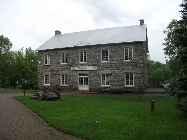 Watson's Mill & Dickinson House — Museum and heritage site
A fully operational 1860s water-powered flour mill and the heritage home of its former owners, at Dickinson Square — Ottawa's only working industrial heritage museum.
Photo: Doug Kerr, CC BY-SA 2.0, via Wikimedia CommonsVisit website
Transit Options
This rural area is not served by OC Transpo rapid transit; residents travel primarily by personal vehicle along Bank Street/Highway 31 and Rideau Valley Drive.
Nearby on This Site
No listings yet in this area.
Official Information
Last verified: August 27, 2026